Friday, May 11, 2012

Weekend Trip

The first stop on our trip was at the Garth Run high strain zone.  Here, we were able to see mezoproterizoic age rock from the basement complex.  Landslides have cleared the mountain sides allowing us to see these magnificent rocks.  The rocks at this outcrop are granite and metamorphosed granite.  These granites showed signs of shearing like budens and grainsize reduction. 

There were also two different folitation orientations.
One foliation is to the left of the pen going from upper right to lower left.  The other is on the right side of the pen going at a steeper angle.

After Garth Run, we went to the Swift Run formation.  The Swift Run formation is between the basement complex granites and the Catoctin flood basalts and was formed from the weathering of the rifted Rodinia.  the Swift Run isn't everywhere and where it is located, there are only sections of it.  The lithology here is sandstone, metamudstone and conglomerates.  In these rocks, we saw primary structures such as graded beds, cross bedding and mud ripup clasts that were parallel to bedding. 

The secondary tectonic structures we saw were folds, and a small s-fold.  We measured the fold to be B4 on the Hugleston Diagram.


We measured the bedding and the cleavage and found that the bedding is shallower than the cleavage.

The next day, we went to Skyline Drive in Shenandoah National Park.  At one of the overlooks, Sandy Bottom overlook, we found tension gashes and skolithos in the rocks used to build the overlook walls.

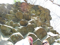
After, we made our way to the Limberlost Trail.  On this trail, we found columnar jointing.  These basalt columns were formed during the breakup of Rodina and the opening of the Iapetus Ocean.  Flood basalt flowed into the openings and as it cooled, columns of basalt were left behind.  Traditionally, basalt columns have equally spaced centers of contractions and equal angles of about 120 degrees.  The ones on the Limberlost Trail were stretched out and the angles were not equal.
The angles on this 115,120,110,113,75,and 155.


The next trail stop was a Compton Peak.  There, we saw more basalt columns except, instead of looking down at them, we had to look up.

 The angles on these columnar joints were equal at about 120 degrees.

On our way out of Shenandoah National Park, we stopped off at the side of the road to look at a feeder dike.  This was one of the many dikes that cut through the rocks and allowed magma to flow to the surface.


Our last stop for the day was a Veach Gap.  Veach Gap is in the Massaunutten Synclonorium in the Vally and Ridge province.  At Veach Gap, there are 6 anticlines.  These anticlines are upright gently plunging , according to the Fleuty or a E4 on the Hudleston diagram.

Thursday, April 19, 2012

Thoroughfare Gap


Thoroughfare Gap is a water gap that cuts through the Bull Run Mountains.  Thoroughfare Gap is located right between the boundaries of Prince William County and Fauquier County with Interstate 66, Virginia State Route 55 and the Manassas Gap Railroad running through it.  This is the site for the civil war battle of Thoroughfare Gap; more commonly known as Chapman’s Mill.  In 1862, a skirmish broke out between the Confederacy and the Union in the Gap.  The confederates won and moved onto winning the Second Battle of Bull Run.

But the history of Thoroughfare Gap goes back even further.  Thoroughfare Gap was formed from a series of mountain building and rifting.  Starting with the building of the Appalachian Mountains in the Taconian orogeny 460 million years ago(Ma).  Africa was slowly making its way towards the area where the Appalachian Mountains would be.  Then Africa slammed in the other land mass creating Pangea and the Appalachian Mountains.  This happened 300-250 Ma.  The evidence from this event is the Appalachian Mountains and the many fractures and joints in the rocks.

Many of these cracks were then filled with Quartz.

210 Ma, Africa slowly started pulling back and created the many rift basins such as the Culpepper Basin as well as the Valley and Ridge, the Piedmont and the Coastal Plains in Virginia. 

At the top of Thoroughfare Gap or the Bull Run Mountains, you are able to see the Blue Ridge Mountains from afar. 

According to the measurements that were taken, all of the outcrops on the Bull Run Mountains are dipping to the East which also means the outcrops on the Blue Ridge Mountains are dipping to the west.  With this information, that would mean that Thoroughfare Gap and the Blue Ridge Mountains were once attached until the rocks were eroded away and pulled apart.


At the bottom of the Bull Run Mountains and Thoroughfare Gap is the Culpepper Basin.  In this basin are the Waterfall Conglomerates, sediments that were eroded from the Appalachian Mountains and deposited in the basin. 
http://www.nvcc.edu/home/cbentley/geoblog/2008/05/western-conglomerates-culpeper-basin.html

While on this trip, the big question we had to answer was where is the stress coming from.  Many of us  took out our compasses and measured the strike and dip of the beddings, joints, and the quartz veins.  Here is a stereonet of the bedding.
As we can see, the bedding dips towards the east which means that the stress is coming from the east.